Suitable For:
Recreational runners of all abilities.
Course Difficulty Level: ![]()
![]()
![]()
![]()
![]()
Cut Off Time: 3 Hours
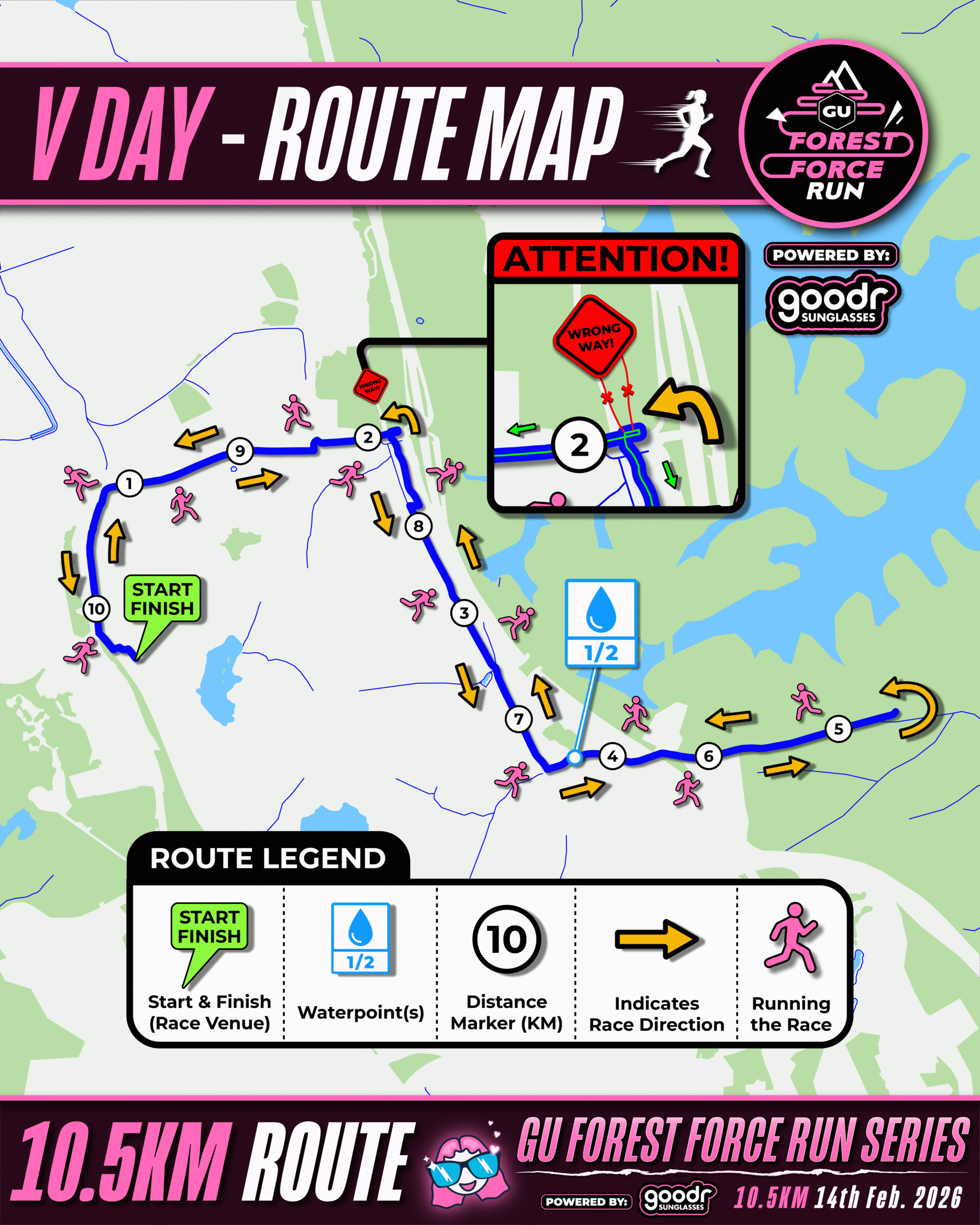
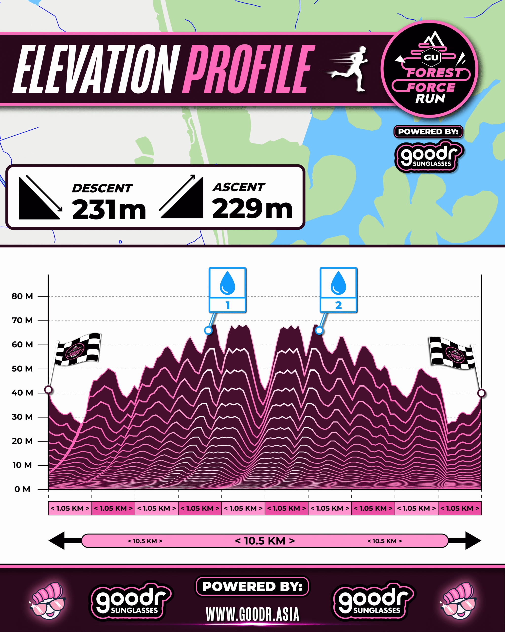
Number Of Waterpoints: 2
Elevation Gain: 229m
The route will involve one road junction crossing. Road marshals will be deployed to ensure the safety of all participants while crossing the road junction. All participants are to strictly abide by the road marshals instructions.
Flag off will commence from 6.45am onwards in a staggered wave format with a interval of 5 minutes between each flag off waves. Full details of flag off timings will be released closer to race day
Start and finish will be at the same location
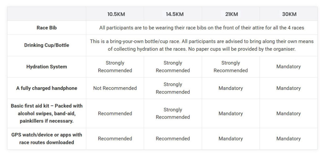
Bag deposit is available at race venue
Portable toilets available at race venue
Suitable For:
Suitable For: Recreational and competiive runners of all abilities. Basically anyone who is up for a fun challenge.
Course Difficulty Level: ![]()
![]()
![]()
![]()
![]()
Cut Off Time: 4 Hours
Number Of Waterpoints: 3
Flag Off will commence from 6.50am onwards in a staggered wave format with a interval of 5 minutes between each flag off waves. Full details of flag off times will be relatively closer to race day
Start and finish will be at the same location
Bag deposit is available at venue
Portable toilets available at venue
14.5km Race Entitlements
- Exclusive event tee shirt.
- Finisher medal.
- Event drawstring bag.
- Race bib.
- Race timing with podium prizes for the winners.
- Exclusive 30% off on all regular priced OOFOS, GU & Sunday Shades products at Running Lab Marina Square (unlimited number of purchases).
- Exclusive 10% off on all regular priced brands and merchandise storewide at Running Lab Marina during REPC – 4/4/26.
- Exclusive 10% off on all Realm Hydration merchandise purchased online (Details to be found in registration confirmation email).
- Complimentary unlimited servings of Electrify electrolyte drinks at finish (race venue).
Suitable For:
Competitive runners of all abilities/ Weekend warriors
Course Difficulty Level: ![]()
![]()
![]()
![]()
![]()
Cut Off Time: 5 Hours
Number Of Waterpoints: 5
Elevation Gain: 562m
The route will involve 3 road junction crossings. Road marshals will be deployed to ensure the safety of all participants while crossing. All participants are to strictly abide by the road marshals instructions.
Flag off will commence from 6.50am onwards in a staggered wave format with a interval of 5 minutes between each flag off waves. Full details of flag off timings will be released closer to race day.
Start and finish will be at the same location
Bag deposit is available at race venue
Portable toilets available at race venue
21km Route Map Links:
Mapometer: https://www.mapometer.com/running/route_5620840.html
Plotaroute: https://www.plotaroute.com/route/3163140
21km Race Entitlements:
- Exclusive event singlet.
- Finisher medal.
- Event drawstring bag.
- Race bib.
- Race timing.
- Exclusive 30% off on all regular priced GU, OOFOS and Sunday Shades products at Running Lab Marina Square (unlimited number of purchases).
- Exclusive 10% off on all Realm Hydration products purchased online (details to be found in registration confirmation email).
- Complimentary unlimited servings of Electrify electrolyte drinks at finish (race venue).
- Exclusive 10% off on all regular priced brands and merchandise storewide at Running Lab Marina Square on REPC date – 20th June.
- UTMB Index accreditation for all UTMB registered participants.
How To Reach Venue:
Dairy Farm MOE Adventure Centre – 30 Dairy Farm Rd Singapore 679058
Nearest Mrt Station – Hillview Mrt Station (use Exit A). 200m walking distance to race venue
Nearest public carpark: Dairy Farm Carpark A (located directly next to race venue)
Venue Google Map Link: https://share.google/2dLK19VINd8Iw9QiW